

A pioneering fully automated habitat mapping and site screening tool has been launched in the UK, said to deliver accurate ecological assessments in minutes.
Powered by biodiversity mapping data company Gentian’s “best-in-class” AI algorithms, True Sight enables ecologists, developers and consultants to rapidly assess site baseline biodiversity to learn areas best suited for development or biodiversity creation.
Gentian’s in-house ecology and AI teams developed the tool “to cut through costly, time-consuming site selection, removing the uncertainty to deliver fast, inexpensive baseline assessments that support early site scoping and selection decisions”.
Faster assessment
A normal site scoping assessment can take from half a day or more and cost around £250-400, Gentian states, limiting the number of sites that can be analysed. True Sight though is said to be 75-90% cheaper per site, allowing multiple sites to be investigated for a fraction of the cost, “in the time it takes to make a cup of tea”.
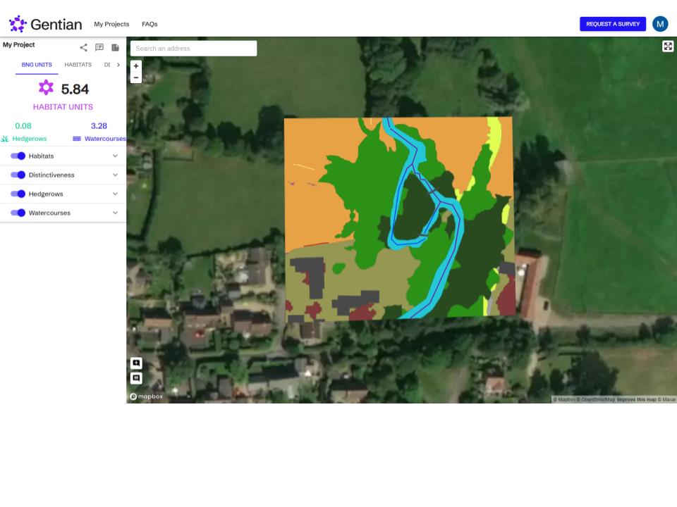
The platform generates an instant biodiversity unit score, with lower scores preferable due to the uplift required under the UK’s Biodiversity Net Gain (BNG) regulations, helping users determine whether a site is suitable for development or offers potential for ecological uplift. “Site baseline biodiversity is key, Gentian adds, “as sites with already high scores make it difficult and expensive to adhere to BNG.”
Major bottleneck
With legal requirements such as BNG placing greater emphasis on accurate environmental data and dramatically increasing workloads for ecologists, the cost and time involved in assessing multiple sites has become a major bottleneck, risking delays to critical development projects, the company explains.
The tool allows landowners and developers to quickly determine baselines of potential sites, to equip ecologists with valuable habitat boundaries and area sizes to allow them to prioritise their more detailed assessments for the full BNG reports.
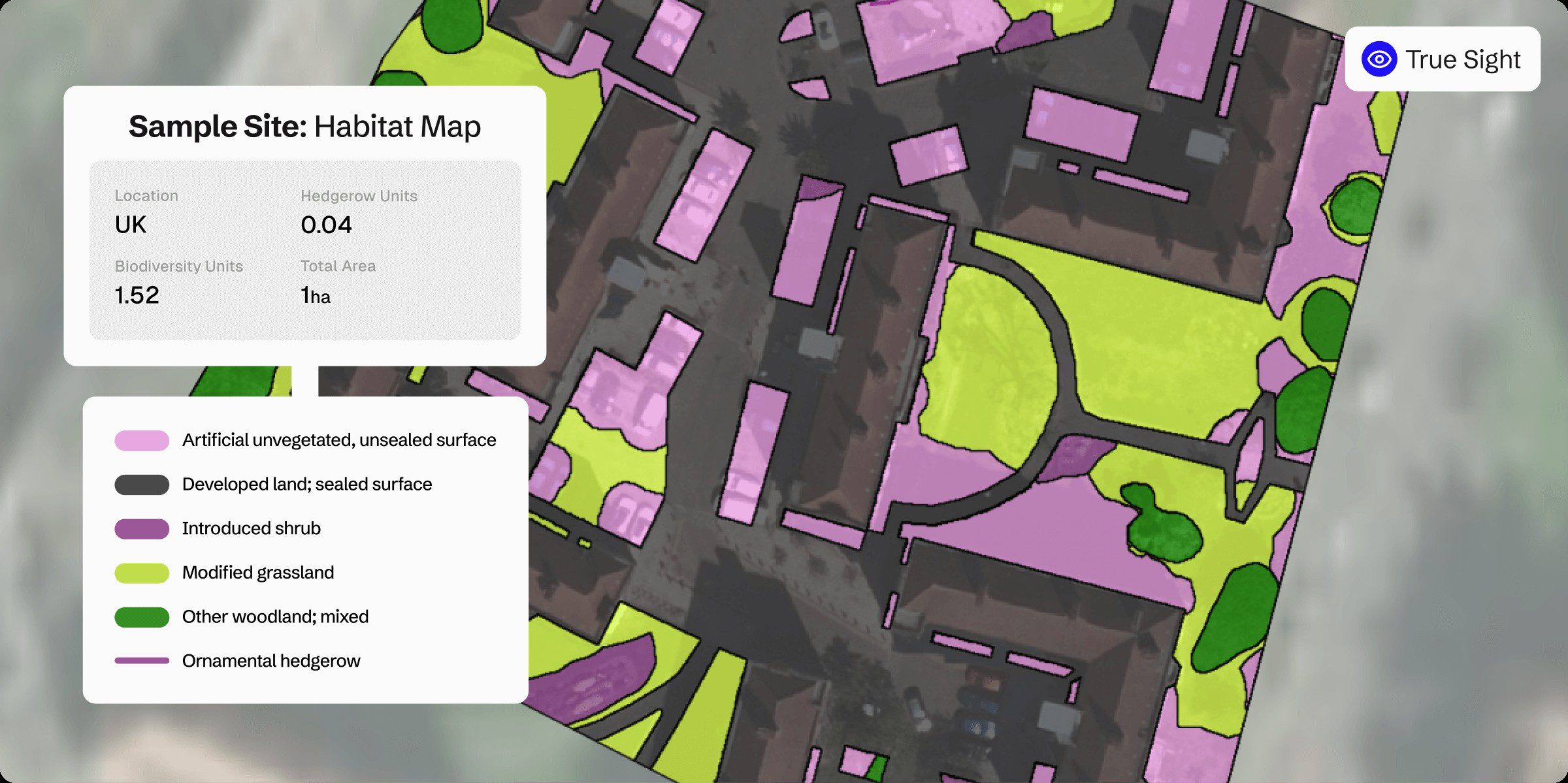
True Sight blends recent high-resolution satellite and aerial imagery (at a precision of 12.5 cm) with Gentian’s proprietary AI engine and is granular enough to distinguish individual trees, small ponds, patches of scrub and other fine-scale habitat features.
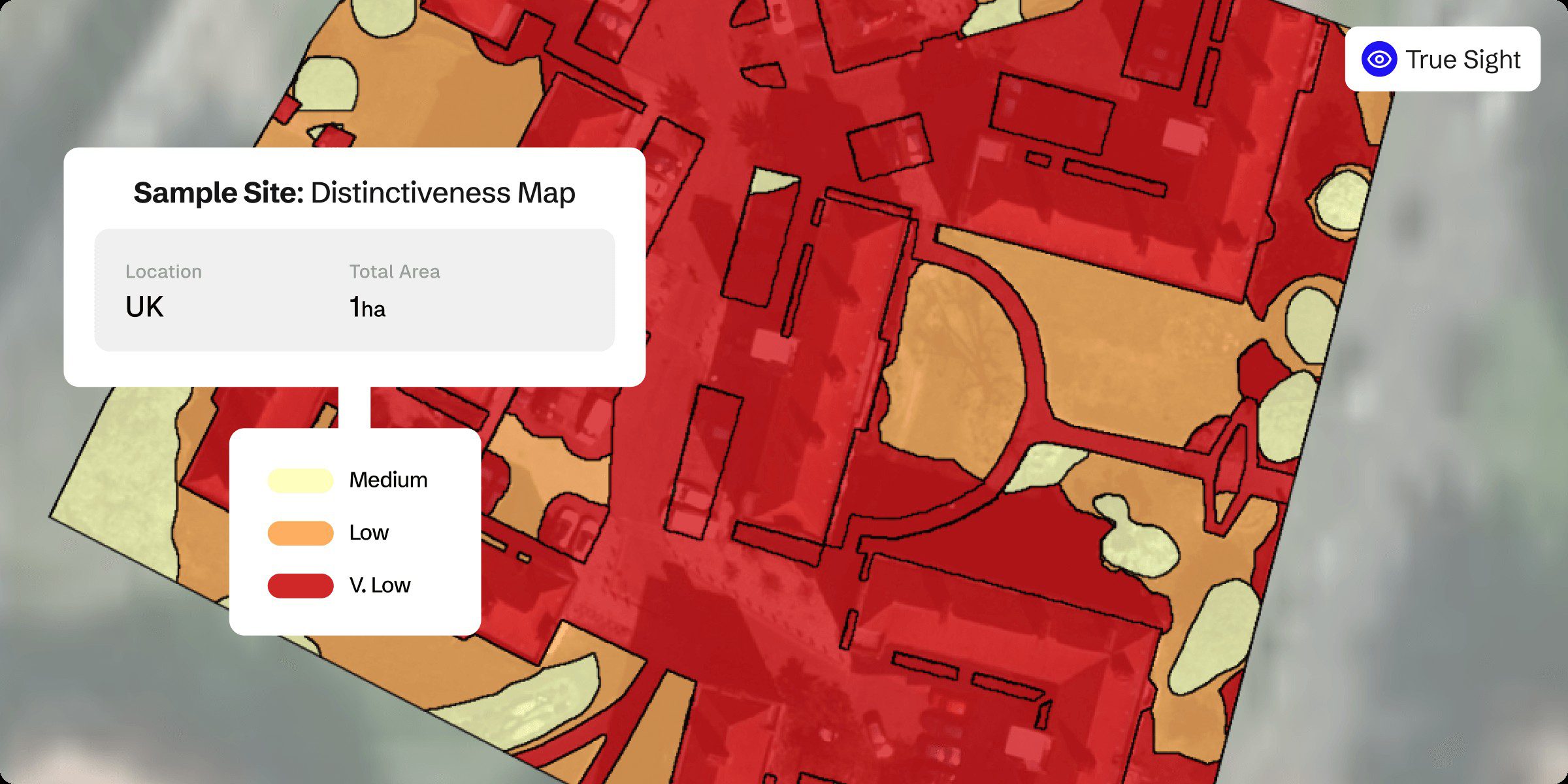
The precision technology analyses landscapes to generate high-fidelity habitat maps and instantly calculates biodiversity unit values, vital for determining features such as minimal mappable units (MMUs), “providing the data developers and ecologists need to make confident, informed decisions”.
The instant biodiversity unit calculation delivers “rapid and reliable” results for 10 of the most common habitat types, as well as priority habitats and linear features, including both hedgerows and watercourses.
API access allows for real-time data, ensuring speed for planners, developers and environmental professionals.
Detailed habitat maps
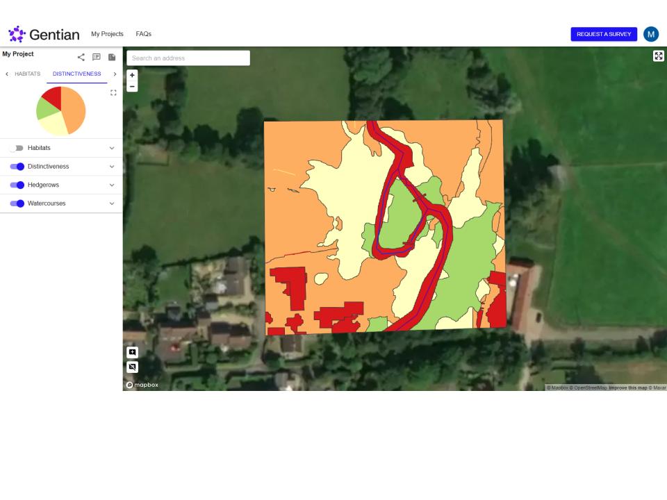
The platform instantly generates professional PDF reports containing detailed habitat maps, distinctiveness maps and biodiversity unit calculations “for simplified stakeholder communication and record-keeping”.
“Our solution cuts through complexity, enabling users to assess biodiversity in minutes rather than weeks and at a fraction of the usual cost,” said Gentian CEO Daniel White. “It’s about empowering smarter, quicker decisions that benefit both business objectives and the natural environment.”
Typically, when using AI-powered mapping solutions, developers and ecologists have faced a trade-off between instant results that are based on low-resolution imagery or waiting weeks for manual analysis with high-resolution images.
Five years of dedicated development in AI and habitat mapping “allows True Sight to eliminate this compromise as the first platform to fully automate biodiversity mapping and unit calculation”.
Gentian True Sight costs £30 for the first hectare and £15 for each subsequent hectare, excluding VAT. Additional options are available to resellers.
Gentian’s Daniel White added: “For landscape architects and designers, Gentian True Sight opens up a completely new way of working with biodiversity data. Instead of waiting weeks for survey results or making early-stage assumptions about a site, they can now generate instant habitat maps and biodiversity unit calculations to guide their design process.
“This means they can test ideas, compare sites, and integrate biodiversity uplift strategies right from the concept stage, all with reliable, fine-scale data.”
Bridging the gap
“Crucially, the tool helps bridge the gap between creative vision and regulatory compliance. With Biodiversity Net Gain requirements now a legal consideration in most projects, designers can quickly understand the biodiversity baseline of a site and make informed choices about where to introduce features such as green roofs, wildflower areas, or other nature positive elements.
“The ability to scope multiple sites or design options at such low cost and high speed compared to conventional methods means landscape architects can bring forward more ambitious, nature-positive designs with confidence.”
“In essence, True Sight is not about replacing ecological expertise but about equipping architects and designers with the insights they need to innovate. By having accurate data at their fingertips from day one, they can unlock more creative opportunities while ensuring projects remain practical, compliant, and beneficial to both clients and the environment.”
https://gentian.io/true-sight.